Die führende Lösung für professionelle Forstwirtschaft
Dynamic Forest ist das digitale Revierbuch für professionelles Forstmanagement. Nutzerfreundlich und plattformübergreifend verfügbar sowie zuverlässig offline einsetzbar, unterstützt es die Planung und Koordination forstlicher Prozesse.
Die führende Lösung für professionelle Forstwirtschaft
Dynamic Forest ist das digitale Revierbuch für professionelles Forstmanagement. Nutzerfreundlich und plattformübergreifend verfügbar sowie zuverlässig offline einsetzbar, unterstützt es die Planung und Koordination forstlicher Prozesse.
Eine Plattform - beliebig viele Nutzer
Weniger Papier, mehr Überblick: Dynamic Forest bringt Ihre Karten und Betriebsdaten in eine zentrale Ansicht. Dank Offline-Karten und automatischer Synchronisierung sind Informationen stets aktuell und für alle Beteiligten verfügbar. Fügen Sie beliebig viele Nutzer hinzu, ohne zusätzliche Kosten.
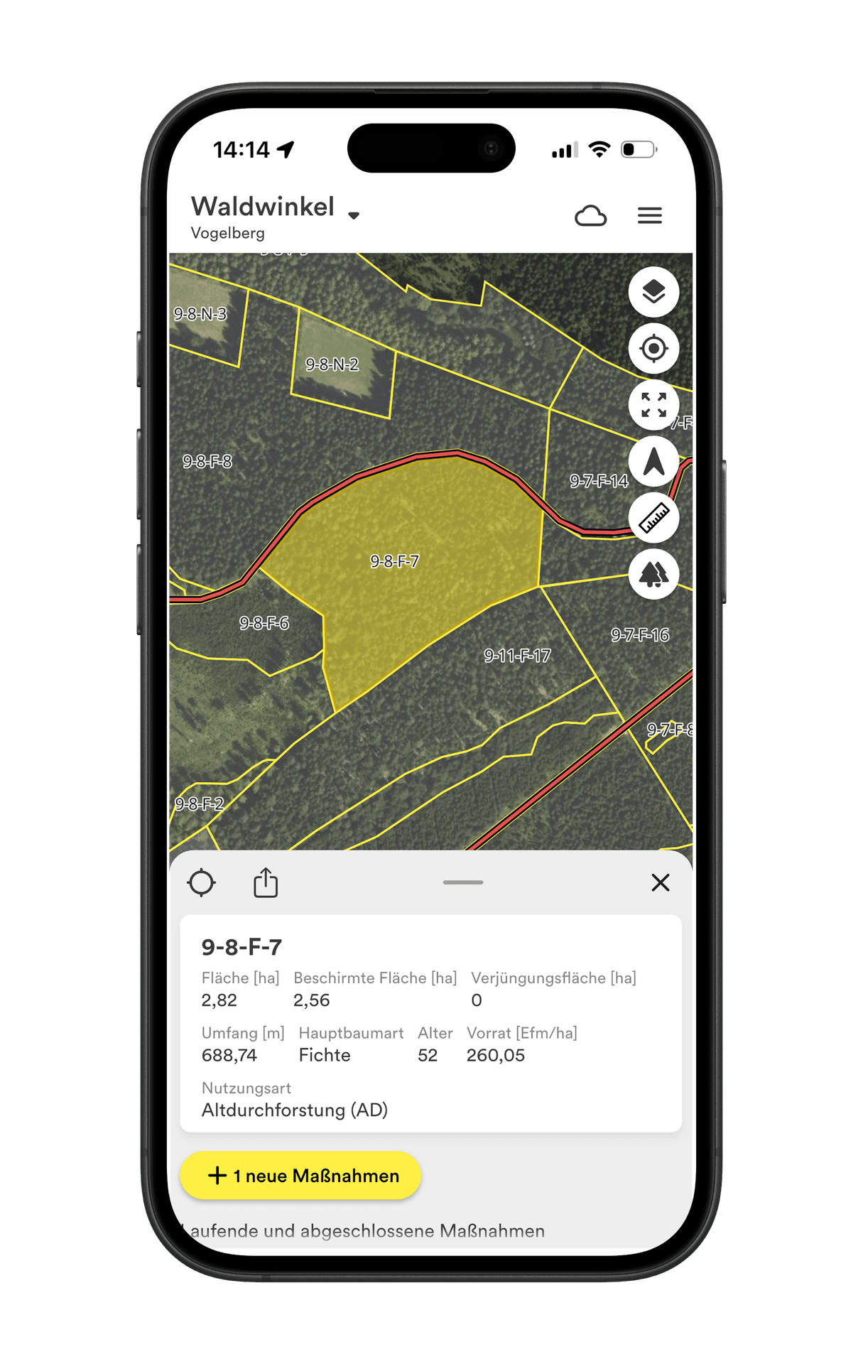
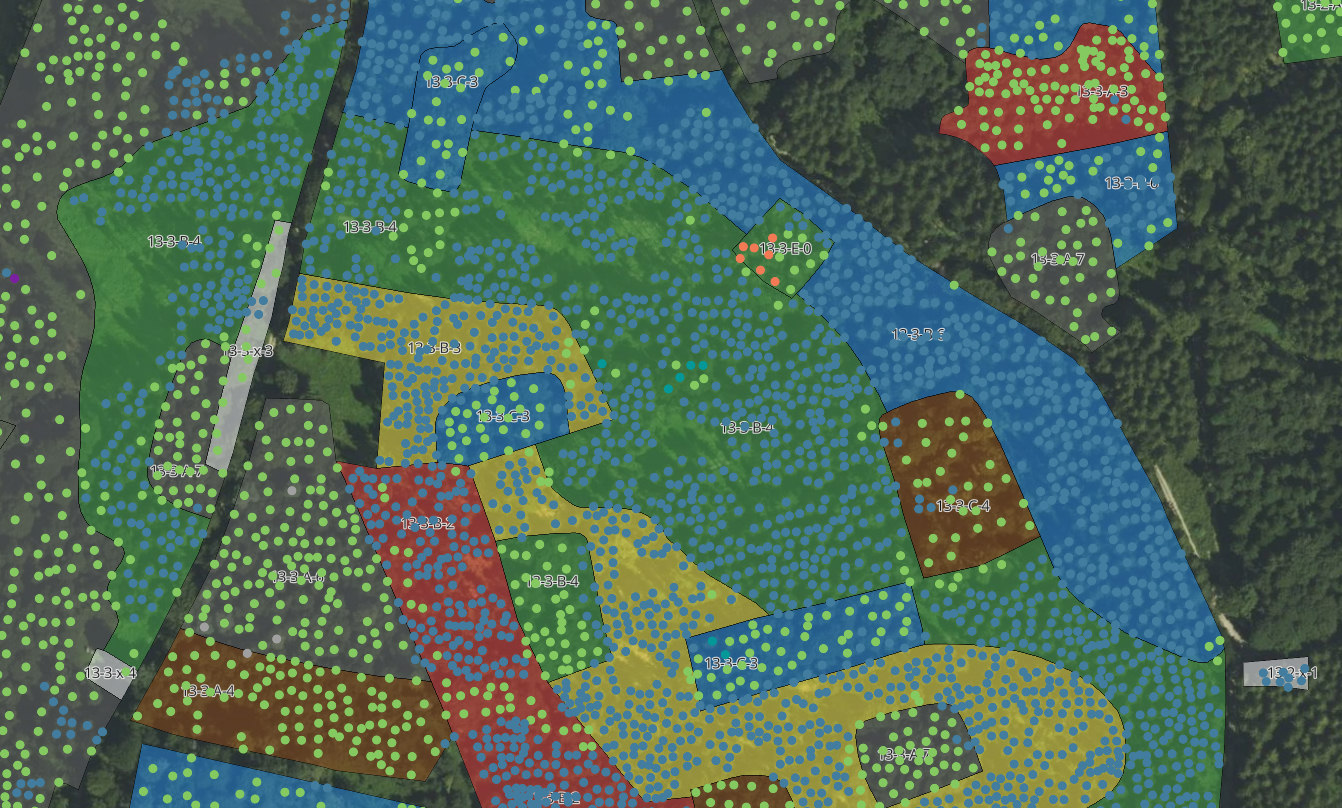
Forstliche Bestandsdaten einsehen & durchsuchen
- Digitale Forstkarte mit Bestandsdaten anzeigen
- Bestandsdaten filtern und durchsuchen
- Planung aus Forsteinrichtung in Bestandsplanung überführen
- Handlungsbedarf ableiten und digital lokalisieren
- Maßnahmenvollzug im Bestand dokumentieren
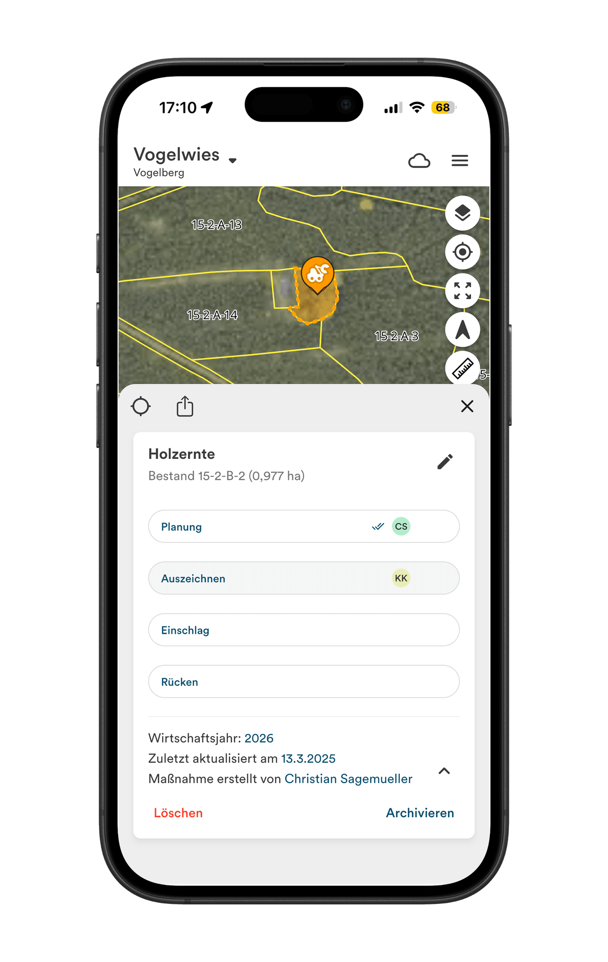
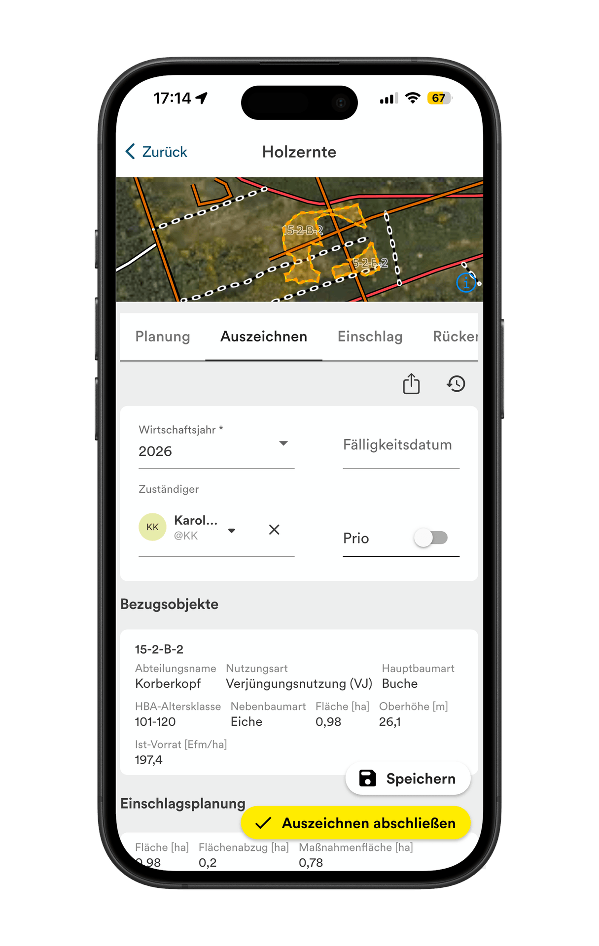
Maßnahmen planen und Vollzug dokumentieren
- Digitale Planung aller forstlicher Maßnahmen
- Planung auf Beständen, Flurstücken oder auf frei gezeichneten Flächen
- Zuordnung zu frei definierbaren Wirtschaftsjahren
- Automatische Berechnung von Pflanzzahlen und Erntevolumen
- Zeiterfassung und Vollzugsmeldung
- Export & Dashboard zur schneller Übersicht im Revier
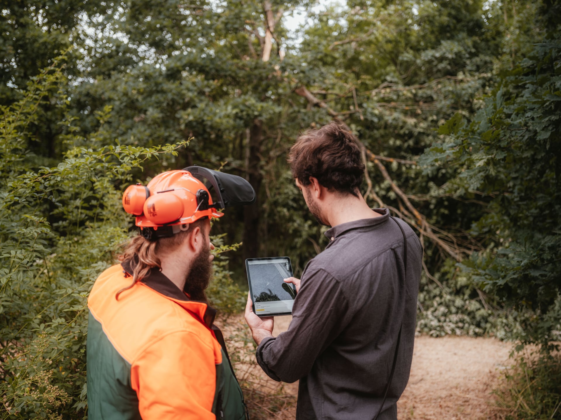
Digitale Arbeitsaufträge erzeugen und mit Unternehmern teilen
- Maßnahmenplanungen nahtlos in Arbeitsauftrag überführen
- UVV konforme Arbeitsanweisungen erzeugen & digital teilen
- Baumarten, Sortimente und weitere Stammdaten eigenständig anlegen & verwalten
- Maßnahmenkarten automatisch erzeugen & editieren
- Unterschriften digital einholen
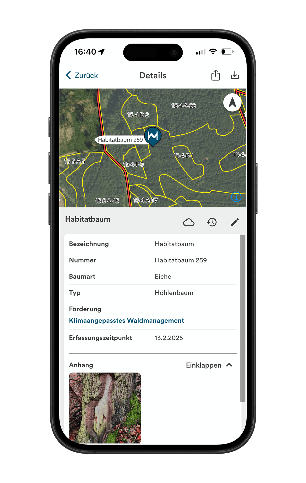
Förderungen verwalten
- Förderungen digital anlegen und verwalten
- Förderungen mit Maßnahmen verknüpfen
- Digitale Karten für Amtsförster/Förderantrag erstellen
- Bewilligungsstatus dokumentieren
- Arbeitsablaufs und Fertigstellungsanzeige erzeugen
- Export der Fertigstellungsanzeige als PDF
- Alle Förderungen je Wirtschaftsjahr nachvollziehen

Kalamitäten in Echtzeit aufarbeiten
- Kalamitäten direkt im Wald digital verorten
- Wichtige Informationen hinterlegen (Baumart, Menge etc.)
- In Echtzeit zur Aufarbeitung synchronisieren
- Status der Aufarbeitung teilen
- Export für amtliche Kalamitätsmeldung
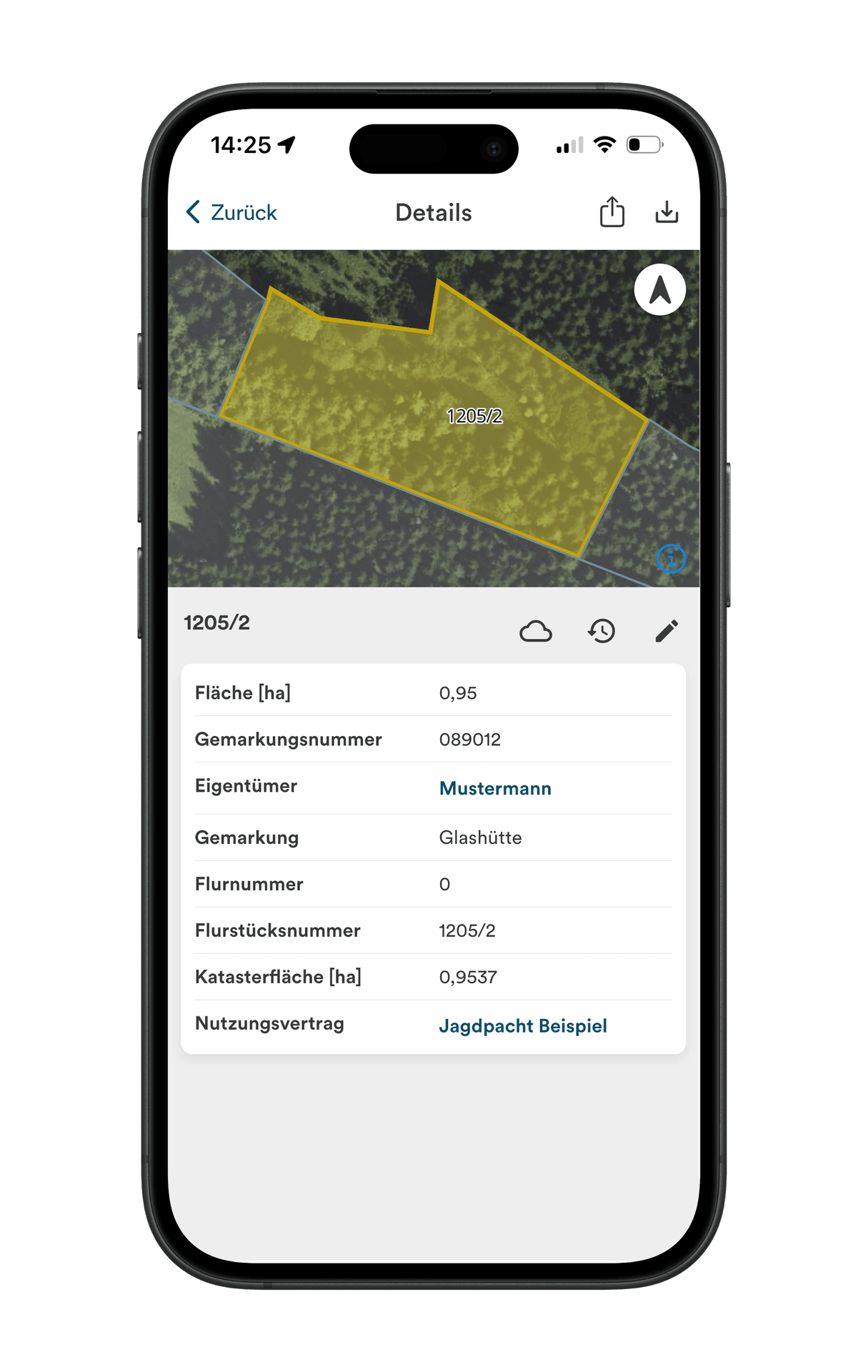
Liegenschaften verwalten
- Flurstücke in zentraler Datenbank verwalten
- Online Zugang zu allen Flurstücken des Vermessungsamts (außer Bayern)
- Flurstücks Zu- und Abgänge einfach erfassen
- Zuweisung der Eigentumsart (Forst, Landwirtschaft etc.).
- Grundbucheintragungen digital hinterlegen und verwalten
- Digitales Vertragsmanagement (Pacht, Überfahrtsrechte etc.)
- Jagdgebietsfeststellung erfassen (Jagdrechte verwalten)
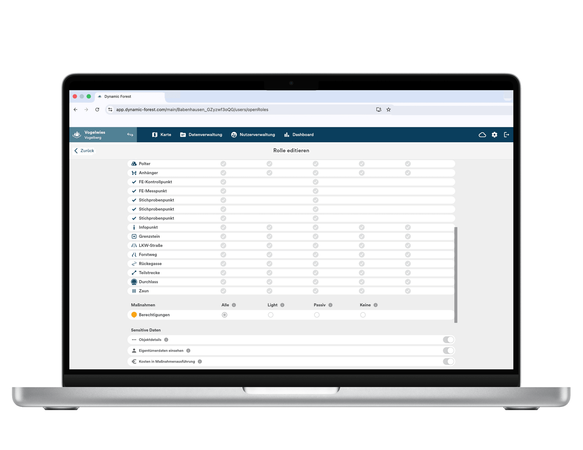
Nutzerrechte und Rollen frei vergeben
- Beliebig viele Nutzer zu Dynamic Forest hinzufügen, ohne zusätzliche Kosten
- Nutzerrechte frei verwalten und Datenzugang einschränken
- Daten mit externen Dienstleistern, Jagdpächtern etc. austauschen
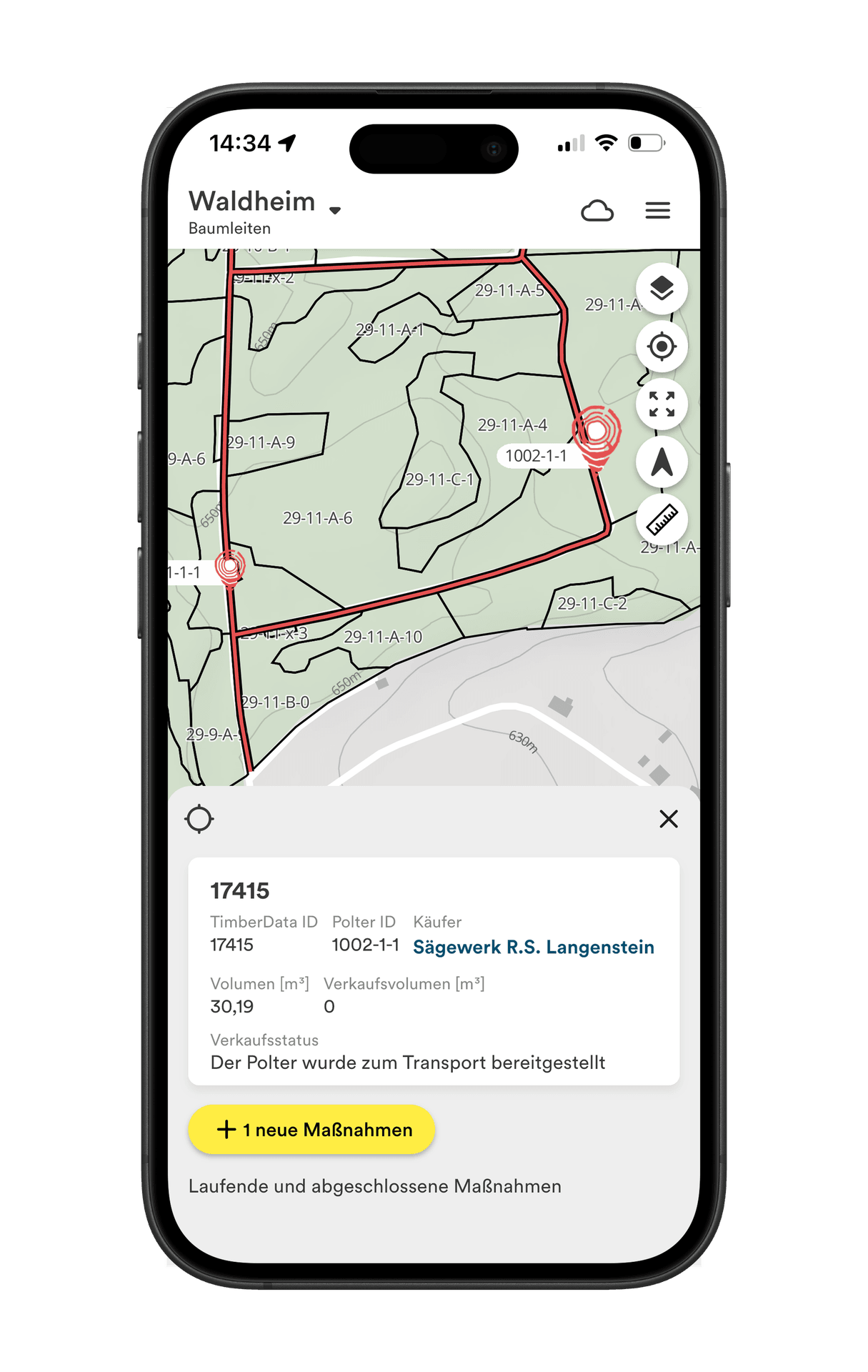
Schnittstelle in Warenwirtschaft
- Live Schnittstelle zu TimberData
- Nahtloser Datenaustausch von Polterdaten, Stammdaten etc.
- Erstellung von Polterkarten mit Abfuhrstatus in Echtzeit
Forest Intelligence
Sehen Sie, was Ihr Wald wirklich zu bieten hat.
Forest Intelligence macht Ihren Wald lesbar. KI-Modelle analysieren Ihren Betrieb auf Einzelbaum- und Bestandsebene – und zeigen Struktur, Bestockung und Risiken, die bisher unsichtbar waren. Das Ergebnis ist keine weitere Karte zum Interpretieren – sondern eine priorisierte Liste konkreter Handlungsempfehlungen.
Jungbestände mit Pflegebedarf
Erkennt Jungbestände, in denen Konkurrenz das Wachstum hemmt – damit Durchforstungen zum richtigen Zeitpunkt geplant werden können.
Überbestockte Bestände
Markiert überbestockte Flächen mit zu hoher Grundfläche – wo eine Durchforstung Stabilität, Vitalität und Zuwachs sichert.
Risikobestände
Markiert Bestände, die besonders anfällig für Trockenheit, Borkenkäfer und Sturmwurf sind – damit Sie Kontrolle und Pflege dort ansetzen, wo das Risiko am höchsten ist.

Plattformübergreifend
Ein System für alle Geräte: mobil im Wald, am PC im Büro.

Offline-fähig
Funktioniert ohne Mobilfunknetz & synchronisiert mit allen Nutzern sobald wieder eine Verbindung besteht.

Unbegrenzte Anzahl an Nutzern
Laden Sie Unternehmer, Jagdgäste, Praktikanten oder Miteigentümer ohne zusätzliche Kosten ein.

Fördermittel & Nachweise
Förderprogramme nachverfolgen und erforderliche Nachweise strukturiert dokumentieren.

Zentrales GIS & Inventar
Alles Kartenmaterial, forstliche Infrastruktur und forstliche Bestandesblätter in einem System.

Einfache Berichterstattung
Nachweise und Übersichten bei Bedarf exportieren – z. B. für Eigentümer, Behörden, oder Zertifizierungsstellen.
Für Privatwaldbesitzer
 Kosten, Einnahmen und Vorgänge jederzeit im Blick.
 - Abstimmung mit Dienstleistern und Auftragnehmern einfacher gestalten.
- Maßnahmen und Aufgaben zur Bewirtschaftung und Verkehrssicherung nachvollziehbar dokumentieren.
Für professionelle Bewirtschafter
 Alle Flächen und Bestände in einer Portfolioansicht.
  Wiederkehrende Vorgänge als Vorlagen anlegen.
  Engpässe und Verzögerungen früh sehen – und Prozesse nachsteuern.
Für forstwirtschaftliche Zusammenschlüsse
 Vorgänge über mehrere Eigentümer hinweg bündeln und zentral steuern.
  Digitale Freigaben: Eigentümer können Maßnahmen direkt in der App freigeben.
  Lückenlose Historie: Entscheidungen, Freigaben und Maßnahmen werden nachvollziehbar protokolliert.

Für Kommunalwälder
- Unbegrenzt viele Nutzer hinzufügen, um die Zusammenarbeit zu verbessern.
- Kosten, Einnahmen und Berichtspflichten übersichtlich nachhalten.
- Maßnahmen und Aufgaben zur Bewirtschaftung und Verkehrssicherung nachvollziehbar dokumentieren.
Ersparnis-Rechner
Ihr Einsparpotenzial mit Dynamic Forest
Passen Sie die Werte an Ihren Betrieb an — das Einsparpotenzial durch Dynamic Forest berechnet sich automatisch.
Eingesparte Arbeitsstunden
567 h
pro Jahr
Kosteneinsparung Verwaltung
9.872 €
pro Jahr
Einsparung Betriebskosten
2.400 €
variabel + fix
Effizienzgewinn Deckungsbeitrag
6.875 €
pro Jahr
Ihre Netto-Ersparnis mit Dynamic Forest
16.657 €
pro Jahr · entspricht ca. 1.388 €/Monat
Diese Berechnung basiert auf Branchendurchschnittswerten und dient der Orientierung, nicht als betriebswirtschaftliches Gutachten.

„Gemeinsam mit unseren Förstern haben wir die wichtigsten auf dem Markt verfügbaren Geoinformationssysteme geprüft und analysiert. Bei diesem Auswahlverfahren stach das Start-up-Unternehmen ocell hervor. Es bot die für unsere Zwecke nützlichste Alternative.”
Maximilian Freiherr von Rotenhahn, Geschäftsführung
Boscor Gruppe
„Die Schnittstelle zu TimberData schafft einen Mehrwert, indem sie es uns ermöglicht, die erfassten Stapel und Mengen in Echtzeit mit dem Verkaufs- und Entnahmestatus zu verfolgen und sie übersichtlich mit der Planung zu vergleichen. Durch die Übertragung der Fäll-Daten mit Bezug zum Geo-Objekt entsteht zudem ein eindeutiger Herkunftsnachweis für das Holz.”
Kerstin Straub, Prokuristin
Wald Plus GmbH
„Digital verfügbare Daten erleichtern unseren Alltag erheblich und haben unsere Prozesse extrem effizient gemacht. Alle Beteiligten profitieren von einem reibungslosen und produktiveren Arbeitsablauf.”
Dominik Mendle, Geschäftsführung
WBV Region Augsburg e.V.
„Was uns wirklich überrascht hat, war wie schnell Dynamic Forest an unsere spezifischen Abläufe angepasst war. Wir haben eine komplexe Organisation mit gewachsenen Strukturen und trotzdem war das System in kürzester Zeit so konfiguriert, dass es sich anfühlt als wäre es für unsere Forstabteilung der Landwirtschaftskammer gebaut worden.”
Peer Rosenhagen, Leitung der forstfachlichen Beratung und Betreuung
Landwirtschaftskammer Schleswig-Holstein


FAQ
Funktioniert Dynamic Forest auch ohne Internetverbindung?
Ja. Erfassen Sie Daten offline, und die Daten werden automatisch synchronisiert, sobald wieder Netzabdeckung besteht.
Wie viele Benutzer kann ich hinzufügen?
Unbegrenzt. Unternehmer, Dienstleister, Jäger, Praktikanten oder Miteigentümer können kostenlos eingeladen werden.
Welche Arten von Maßnahmen kann ich planen?
Pflanzungen, Pflegeläuterungen, Holzernte, Kalamitätsaufarbeitung, Verkehrssicherung – alles kann geplant und nachverfolgt werden.
Kann ich Fördermittel & Nachweise verwalten?
Ja. Dynamic Forest unterstützt Sie dabei, Fördervorgänge und zugehörige Verpflichtungen nachzuhalten und relevante Maßnahmen sowie Nachweise strukturiert zu dokumentieren – z. B. im Kontext von Auflagen und Verkehrssicherung.
Wie sieht es mit der Verwaltung mehrerer Eigentümer (FBGs) aus?
Dynamic Forest unterstützt die Verwaltung vieler Eigentümer in einem gemeinsamen System. Vorgänge lassen sich eigentümerübergreifend bündeln, Arbeiten über mehrere Dienstleister koordinieren und Freigaben direkt in der App einholen.
Moderne Forstwirtschaft braucht Werkzeuge, die im Alltag funktionieren
Dynamic Forest verbindet Karten, Maßnahmen und Dokumentation in einer Plattform – im Wald und im Büro.
Demo buchen