

Calamity management with Dynamic Forest: from bark beetle tree to report
When a major damage event hits – a storm, a drought or a bark beetle outbreak – speed determines how bad the damage gets. Every infested tree left standing too long provides breeding ground for the next bark beetle generation, and the salvage timber loses value with every week it waits.
We covered how sharply such damage has increased in a separate article on calamities as a growing threat to forests. This article answers the follow-up question: what does salvage logging actually look like when the whole process runs digitally?
Calamity management in four steps
Clean-up does not end with the timber at the roadside. From the first find to the completed report there are four steps, and in practice they are usually spread across separate tools: a map in the car, a phone call to the contractor, a spreadsheet at the end of the year.
- Find and capture – record the infested tree in the stand before it is forgotten.
- Maintain status – make the state of the clean-up visible to everyone involved.
- Coordinate the work – assign felling and forwarding, with responsibility and a deadline.
- Evaluate and report – filter the data and export it as a report.
With Dynamic Forest these four steps run in one system. That is faster than hand-drawn maps, and the data stays traceable for the years that follow.
Step 1: Capture the tree where it stands
Recording happens in the stand. In the mobile version, a new calamity is added on the forest base map, either by GPS location or as a manually placed point.
The details are then entered in a form: label, status, capture time and optional fields such as type of infestation, estimated volume and tree species. The capture time is set automatically but can be corrected if the tree was actually spotted days earlier.
This also works without mobile coverage: the mobile version keeps the map and data on the device, so calamities can be created, edited and updated offline. As soon as a connection is available again, the app transfers the changes automatically and the tree appears on your colleagues' maps.
Step 2: Track salvage progress on the map
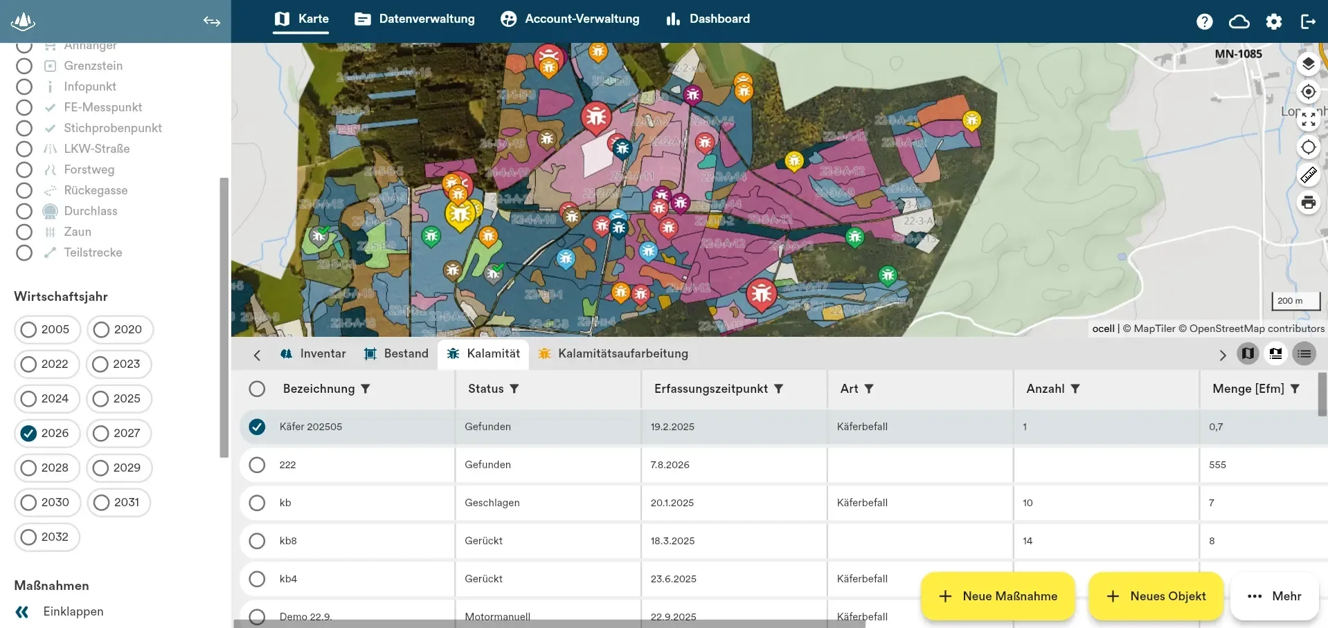
Every calamity carries a status describing how far the work has progressed – from the first record to the forwarded timber. On the map this shows as the colour of the point: trees that have been found are red, felled trees yellow, forwarded trees green.
The benefit becomes obvious as soon as several people are working the same district. When someone records a tree, it appears on their colleagues' maps straight away, and whoever fells one changes the status with a single tap. Zoom out, and the result is an overview of the state of an entire management unit.
Alongside these three, there are further statuses for the intermediate steps of the clean-up, such as “motor-manual”, “directional felling”, “pre-extraction” or “schedulable”. “Schedulable” means the harvester can drive up to the tree directly.
Step 3: Assign felling and forwarding to contractors
For a single tree a link is enough: colleagues with access to Dynamic Forest open exactly that tree and land in the same view. For a larger infestation, a collective work order pays off. Filters on status and capture period produce a selection for which a single measure can be planned.
What matters is the assignment. Felling and forwarding are assigned separately, each with a responsible person and a deadline. The work instruction – motor-manual harvesting, for instance – can be defined once at district level and reused. When the order is sent, the assignee receives a notification on their mobile device and by email, and sees the same locations and planned volumes.
Once they mark the felling as complete, the affected calamities change colour and status on the map.
Step 4: Export the salvage report
The calamity report comes last. The list view holds every calamity in a district and filters by status, capture period and type of calamity. The filtered selection can be exported as an Excel file with all recorded attributes: capture time, who recorded the tree, type, when the clean-up happened and the volume involved. For further processing, it can also be exported as a geo file in Shape or GeoJSON format.
What changes in practice
The gain lies less in individual features than in the process no longer being spread across several tools. The find, the assignment and the report all draw on the same data. Nobody has to call around to learn where things stand, and no calamity slips through the gap between map, phone note and spreadsheet.
Would you like to see how Dynamic Forest can support you and your team? Book a free demo with one of our experts.